

There is a particular kind of magic that happens when you step out of a car on Colima Road in Whittier, California, and suddenly realize that the noise of the 605 freeway has gone quiet. Not silent — this is Los Angeles, after all — but quiet enough. Quiet enough that you can hear the California sagebrush rustling against itself, or the dry creak of eucalyptus in a crosswind, or the tiny, cat-like call of a bird so rare it took an act of federal law to protect it.
That bird is the coastal California gnatcatcher. And the place where it has made its home — against considerable odds, in a landscape that was drilled, pumped, stripped, and nearly forgotten — is the Arroyo Pescadero Trailhead, a gateway into one of the most surprising green spaces in all of Southern California.
This is not a trailhead that will make magazine covers. It does not deliver sweeping panoramas of snowcapped peaks or photogenic waterfalls. What it delivers instead is something rarer in the modern urban context: genuine wildness, layered history, and the quiet satisfaction of a walk that earns its keep not through spectacle but through subtlety. For a region where open space is a resource more contested than water, Arroyo Pescadero is something close to a miracle.
The Lay of the Land: Where You Are and How to Get There
The Arroyo Pescadero Trailhead sits on Colima Road in Whittier, serving as the main access point to the trail network in the Puente Hills Preserve. The address — 7531 S. Colima Road, Whittier, CA 90605 — is the kind of location that requires no particular navigation wizardry. From the 60 freeway, you head south on Colima, pass through the residential neighborhoods that fan out from the base of the hills, and eventually arrive at a gated entrance on the west side of the road, sitting just across from Murphy Ranch’s baseball fields.
The entrance announces itself with iron gates decorated with wildlife motifs — a small but deliberate gesture that signals you are crossing a threshold. The parking lot is right off Colima Road, and the trail starts paved before quickly giving way to the dirt fire roads that define the character of the place.
The gated trailhead provides a restroom, onsite parking, ADA access, a drinking fountain, and equestrian staging for trail users. Near the trailhead, educational kiosks can be found along a short ADA-friendly decomposed granite trail surrounded by restored habitat. Nearby, a rammed-earthen amphitheater at a scenic vista offers a rest area for hikers.
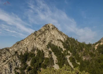
The rammed-earthen amphitheater deserves a moment’s attention in its own right. It is not a grand structure — it seats a few dozen people at most — but it is thoughtfully placed, catching a sightline across the canyon toward the wider hills. On a clear winter morning, you can see what looks like the edge of the Pacific from that little stage of compacted earth. On good days, the view from the start of the hike stretches almost to the shoreline. For a preserve tucked into the middle of an urban grid, the sense of distance is genuinely startling.
An Old Oil Field, Remade
To understand Arroyo Pescadero properly, you have to reckon with its industrial past. This is not pristine wilderness that has always looked as it does today. It is, in a very real sense, a success story — one of redemption and restoration.
The Arroyo Pescadero area of the Preserve is the site of a former oil field, and the trails you walk today were once oil company roads used by drilling equipment and service vehicles. The Puente-Chino Hills are made up of sedimentary rocks of the Puente Formation, deposited from five to fifteen million years ago, and associated with petroleum resources that have been explored and exploited in the Los Angeles region since the late 1800s. The hills you see rising above the trail were once riddled with pump jacks and service roads. The landscape bore all the marks of industrial extraction.
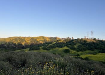
What happened next is the kind of story environmental advocates rarely get to tell with a happy ending. What was once a moonscape with tree stumps and bare dirt has been restored with blankets of purple sage, yellow sunflowers, and milky buckwheat. The restoration of the East Colima coastal sage scrub area was a deliberate, science-led effort, and its results have been measurable and profound.
The work did not happen overnight. It required years of invasive species removal, native plantings, careful monitoring, and the kind of institutional patience that public land management rarely musters. But the payoff came quickly enough to astonish even the people doing the work. Within two years of habitat restoration efforts, the first breeding pair of California gnatcatchers arrived — and nesting pairs have been detected and monitored in subsequent years. That a federally threatened species would recolonize a former oil field within two years of restoration is not just ecologically significant. It is, in the language of conservation biology, a vindication.
The Gnatcatcher and What It Means
The coastal California gnatcatcher (Polioptila californica californica) is a small bird — four to five inches long, weighing less than a quarter of an ounce — that carries an outsized ecological and political significance. Until the late 1980s, the California gnatcatcher was regarded as just a local form of the black-tailed gnatcatcher. With its recognition as a full species, it also became endangered, its limited habitat along the southern California coast increasingly taken over by housing tracts and other developments.
California gnatcatchers live in coastal sage scrub, a low shrubby habitat that is also home to other specialized animals and plants. This is precisely what makes Arroyo Pescadero so significant: the restored habitat here is not a simulation of what once existed but a genuine return of the real thing, confirmed by the birds themselves.
The gnatcatcher’s call — that thin, complaining mew that sounds more feline than avian — is one of the sounds of a healthy coastal scrub ecosystem. Hearing it at Arroyo Pescadero, on a trail that thirty years ago ran past oil field infrastructure, carries a particular emotional resonance. Nature, it turns out, is willing to return when we stop treating it as a problem to be solved.
The Puente Hills Preserve supports various habitat types including coastal sage scrub, chaparral, oak and walnut woodlands, and riparian vegetation, with documented species spanning four amphibians, nine reptiles, 124 birds, and 30 mammals. The Arroyo Pescadero area is a functioning slice of that larger ecological tapestry, and the gnatcatcher is its most visible emblem.
The Trails Themselves: What Awaits the Hiker
The trail system accessible from the Arroyo Pescadero Trailhead is organized around three main routes, each with a different character and a different ask of the person walking it.
The Bob Henderson Loop Trail
The relatively level, two-mile Bob Henderson Loop Trail is a popular option and perfect for families. Named for Bob Henderson — a Whittier city councilman who became one of the most important champions of the Puente Hills preservation effort — the loop is the trail most visitors will walk first, and likely most often. It is accessible without special gear, manageable for children and older adults, and generous enough in its rewards to make even experienced hikers glad they came.
The Arroyo Pescadero heads northeast, approaches the end of the arroyo, then loops back to the southwest — an oval loop that drops in altitude from the trailhead and keeps you well below the canyon tops the entire way. The drop is gentle. The ascents, when they come, are unhurried. This is not a trail designed to test your cardiovascular limits. It is designed, whether intentionally or not, to slow you down enough to pay attention.
Perhaps the most immediately striking feature of the trail near the trailhead is the unusual structure of the trees, which curl over to nearly touch the trail itself, creating a kind of natural arcade. Walking beneath these arching branches in the early morning, when the light is still low and filtering through the canopy, the trail has an almost architectural quality — not grandiose, but intimate in a way that larger, more famous trails rarely achieve.
The Deer Loop Trail
Breaking off from the main Arroyo Pescadero trail, the Deer Loop is a shorter option at 0.8 miles. Following the Deer Loop brings you quickly to another fork, and heading right takes you up an easy hill, while the left fork leads to a separate parking area and alternate trail entrance. The loop passes through a section dominated by eucalyptus — not a native species, but a presence so embedded in the Southern California landscape by now that its absence would feel conspicuous.
Near the Deer Loop, signs announce that native habitat restoration is in progress, and the contrast between the restored and non-restored sections is visible even to an untrained eye — the northern sections filled with California pepper trees and few eucalyptus, while the Deer Loop area is almost entirely eucalyptus. This ongoing transition, the slow replacement of introduced species with natives, is one of the quiet dramas the trail enacts over time. Come back every few years, and the character of the landscape will have shifted.
In the right wind conditions, turkey vultures, hawks, and crows can be spotted riding the thermals with wings fully extended, sometimes hanging nearly motionless against the breeze. The raptors above, the gnatcatchers in the scrub below — for birdwatchers, even a modest loop through this preserve offers a compelling field day.
Arroyo San Miguel Trail and Beyond
For hikers wanting more mileage, the Arroyo San Miguel Trail extends east of Colima Road, adding 1.8 miles with 360 feet of elevation gain. This trail is the one subject to the strictest ecological protection: because of the presence of ecologically sensitive resources, dogs are not allowed on the Arroyo San Miguel Trail, and bicycles are excluded from the Bob Henderson Loop and the adjoining Deer Loop Trail.
For those seeking a genuine half-day effort, the Arroyo Pescadero to Workman Hill and Worsham Canyon route covers 9.1 miles as a loop, with 1,597 feet of elevation gain and an average completion time of around four and a half hours. This is a different category of hike altogether — one that takes you into the more remote and less-visited reaches of the preserve, where the city falls away and the hills become genuinely large.
The Bigger Picture: The Puente Hills and Why They Matter
To walk the Arroyo Pescadero trails with full appreciation, it helps to understand the larger ecological and political context in which they exist.
Since the early 1990s, approximately $220 million of public funds have been invested in the conservation of the Puente Hills, funded through grants, developer mitigation payments, and a per-ton fee at the Puente Hills Landfill. The preserve that resulted from this effort — the 3,870-acre Puente Hills Preserve — is managed by the Puente Hills Habitat Preservation Authority, which oversees everything from trail maintenance to habitat restoration to wildlife monitoring.
The Puente Hills corridor is described by conservationists as unique because it is so entirely surrounded by dense development — there is nothing comparable to it in California. What exists here is not simply a park in the conventional sense but a functioning ecological corridor, a passage through which animals can move between fragmented patches of habitat in one of the most urbanized regions on Earth.
Biologists have documented mountain lions, salamanders, orange-throated whiptail lizards, and brown king snakes in the corridor, alongside hundreds of other species. The bobcat known as ZEK, documented in the East Colima area near Arroyo Pescadero, became something of a local celebrity — a living proof-of-concept that urban wildlife corridors can work when protected properly.
Visitation to the Preserve has surged dramatically over the years, with daily visitor counts jumping from 228 in 2005 to approximately 2,600 by 2016. That tenfold increase reflects broader trends in Southern California’s relationship with public land — as the region’s population grows and open space becomes scarcer, the remaining fragments become proportionally more precious.
Practical Matters: Going Prepared
The experience at Arroyo Pescadero is enhanced considerably by going in with the right expectations and the right preparation.
The trailhead is open sunrise to sunset, seven days a week when trails are open. The preserve observes a firm and important closure rule: trails are closed for 48 hours after rain. This is not bureaucratic excess — the dirt fire roads become genuinely hazardous when wet, and the ecological impact of heavy foot traffic on rain-softened soil can set back years of restoration work in a single afternoon. Checking the Habitat Authority’s website before heading out on any day following precipitation is simply part of the responsible visitor’s routine.
Parking is free and the lot is reasonably sized, though on weekend mornings in spring — when the wildflowers are at their peak and every Angeleno with a sudden outdoorsy impulse seems to converge on the same locations — arriving early is advisable. The restroom facilities are clean and well-maintained. The drinking fountain near the trailhead is functional.
For those with mobility considerations, the Arroyo Pescadero Trailhead is one of only three ADA-accessible trailheads in the Puente Hills Preserve, with a short decomposed granite interpretive trail near the entrance that can accommodate a range of mobility devices.
Hikers with dogs have a limited but usable option: dogs are permitted only on a designated 100-yard section of trail, and the remaining trails are clearly marked as no-dog zones. This restriction reflects the preserve’s serious commitment to its sensitive wildlife populations, particularly the gnatcatcher, which is highly susceptible to disturbance during nesting season. It is one of the preserve’s few firm rules, and one worth respecting without resentment.
For trail runners, the Bob Henderson Loop and the fire roads provide a good surface for easy-to-moderate running. The wide dirt fire roads are particularly well suited to off-road strollers as well. Cyclists should note that mountain bikes are not permitted on the main loop trails — a restriction that has helped maintain the quiet character of the hike and reduced erosion on the more sensitive sections.
The Best Time to Go and What to Look For
Southern California’s trail seasons are not as dramatically defined as those in other parts of the country, but Arroyo Pescadero has a distinct calendar that rewards strategic visiting.
Spring — roughly late February through April — is the peak wildflower season. The hills come alive with wildflowers in spring, particularly around the lower wooded sections at the base of the hills. The native encelia, commonly known as brittlebush, coats the exposed slopes in yellow. Wild mustard waves from any patch of disturbed ground. Purple sage fills the air with a scent that Californians who grew up near it associate viscerally with this exact kind of foothill landscape on a warm spring afternoon.
Spring is also the gnatcatcher’s nesting season, which runs from late February through mid-July. During these months, the birds are most vocal and most visible, singing territory from the upper branches of sagebrush and responding defensively to other pairs. Walking the Arroyo San Miguel Trail corridor in late March on a clear morning, you have a reasonable chance of hearing the species’ distinctive call from multiple directions simultaneously.
Summer is feasible but demands early starts. The terrain offers limited shade, and the exposed fire roads can become genuinely hot by mid-morning. Carrying at least 1.5 liters of water per person is a minimum, not a suggestion. The morning light in summer, however, is exceptional — long horizontal rays cutting through the scrub and illuminating the spider webs that string between every branch like small nets.
Fall and winter bring cooler temperatures and, in years with any meaningful precipitation, greened hills and cleared air. After the first significant rains of the season — once the mandatory 48-hour closure has passed — the transformed landscape rewards the patient visitor with a freshness that Los Angeles rarely delivers.
The Deeper Reward
There is a particular genre of natural area that does not perform. It does not thrust dramatic formations in your face or engineer scenic overlooks for the Instagram generation. It simply exists, quietly, doing the work that all healthy ecosystems do: cycling nutrients, supporting species, filtering water, holding soil.
Arroyo Pescadero is that kind of place. Its rewards are proportional to the attention you bring. Walk quickly, headphones in, chasing a fitness metric, and you will finish the loop with your heart rate slightly elevated and your memory carrying little. Walk slowly, stop when you hear a bird, crouch to look at what is growing through the decomposed granite near the trail edge, and the experience changes character entirely.
The oil field that once occupied these hills extracted something from the landscape. The conservation work that followed has been putting things back, slowly and methodically, for decades. What was bare dirt and tree stumps has become lush coastal sage scrub — a habitat type that has been overrun by housing tracts and shopping centers across Southern California. Each nesting pair of gnatcatchers represents not just a biological data point but a small, feathered referendum on what is possible when people decide a piece of land is worth protecting.
Sometimes you don’t need to summit a mountain or hike among crowds at an overly popular trailhead to have a great experience in nature. Sometimes it’s the undiscovered trails — the underdogs of the hiking world — that hold the most to offer.
Arroyo Pescadero will not make you feel like an explorer conquering untamed wilderness. It will not give you a peak to brag about or a summit selfie for your social media grid. What it will give you, if you let it, is something considerably more valuable: a few hours in a place that has come back from a kind of death, buzzing with life that decided, against the odds of an urban Southern California landscape, to stay.
That is worth the drive down Colima Road. It is worth the early alarm on a Saturday morning. It is worth every minute you spend standing still on a fire road, listening for the thin, persistent call of a tiny grey bird that chose this hill, this scrub, this restored former oil field, to make its home.
Arroyo Pescadero Trailhead is located at 7531 S. Colima Road, Whittier, CA 90605. Open sunrise to sunset. Trails close 48 hours after rain. Free parking. ADA accessible. No dogs on main trails. No bikes on loop trails. For current conditions, visit habitatauthority.org.


