

Los Angeles County has never been short on paradox. A sprawling metropolis of concrete freeways and glass towers sits barely a stone’s throw from some of the most dramatic wilderness in the American West. And yet, even among seasoned Angelenos who consider themselves well-versed in local trails and open spaces, one destination continues to fly under the radar. Azusa Wilderness Park — also known as Azusa River Wilderness Park or simply El Encanto — is a 40-acre pocket of raw, unvarnished nature tucked right where the San Gabriel Canyon spills into the flatlands of the San Gabriel Valley. It is not flashy. It does not trend on social media the way Runyon Canyon or Eaton Canyon does. But for those who find it, it tends to leave a lasting impression.
This is a place where the sound of rushing water replaces the drone of traffic within minutes. Where a gentle, accessible trail leads families, dog walkers, trail runners, and solo wanderers alongside one of Southern California’s most important rivers. And where a layered history — from its days as a canyon roadhouse to its current stewardship under the Watershed Conservation Authority — gives the landscape a richness that rewards curiosity.
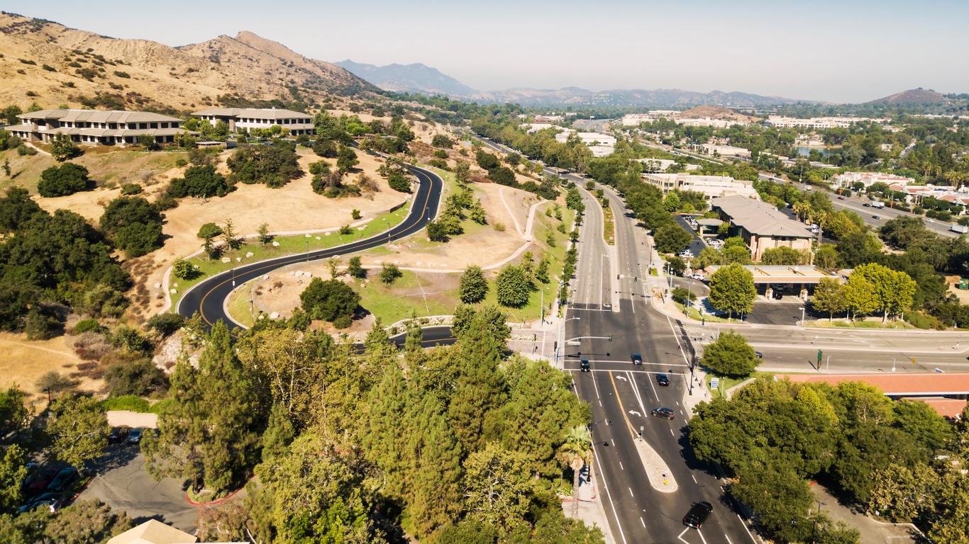
Where Exactly Is Azusa Wilderness Park?
The park sits at 100 Old San Gabriel Canyon Road in Azusa, California, 91702. For those navigating from the freeway, the route is straightforward: take the I-210 to CA-39 (Azusa Avenue), head north, and follow the road as it begins to climb into the foothills. The park entrance and its large parking lot appear on the right, marked by a prominent sign reading “El Encanto” — a name that has clung to this spot for decades.
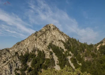
Geographically, the park occupies a remarkable position. It is perched right at the gateway to the San Gabriel Canyon, the point where the San Gabriel River emerges from the Angeles National Forest and begins its long, 40-mile journey south to Seal Beach and the Pacific Ocean. This location makes the park both a literal and symbolic threshold between the urban flatlands and the mountain wilderness above.
The city of Azusa itself has long branded this corridor as its recreational crown jewel, and the San Gabriel Canyon Gateway Center — the ranger station at the canyon’s entrance — sits nearby, reinforcing the area’s identity as a departure point for deeper mountain adventures.
The El Encanto Story: From Roadhouse to River Park
Every good park has a backstory, and Azusa Wilderness Park’s is more colorful than most.
The site where visitors now park their cars and lace up their hiking boots was once home to the El Encanto restaurant, a canyon roadhouse that served generations of travelers heading up Highway 39 into the San Gabriel Mountains. The restaurant was a fixture of the canyon community — a place to fuel up before a day of fishing, camping, or simply driving the winding mountain road. Over time, however, the building fell into disuse, and the property changed hands.
The turning point came when the Watershed Conservation Authority (WCA), in collaboration with the City of Azusa, purchased the former restaurant site. The acquisition set in motion a planning effort that would reimagine the property as something far more ambitious than a parking lot with a view. The resulting El Encanto Azusa River Wilderness Park Master Plan, filed with the state in 2008, outlined a vision that included habitat restoration along the San Gabriel River bank, expanded hiking and biking trails, drainage improvements, educational and interpretive displays, and the restoration and adaptive reuse of existing buildings on the site.
The master plan was a statement of intent: this was not going to be a passive park. It was designed to actively restore the natural environment while simultaneously opening the canyon’s mouth to a broader public. The plan called for reconfiguring and reducing the parking lot’s footprint, replacing impervious surfaces with native plantings, and creating a “special use area” for community programming and environmental education.
While the full scope of the master plan has unfolded gradually — as is often the case with publicly funded conservation projects — the park today reflects that original ambition. The Hilda L. Solis River Overlook, located near the trailhead, provides interpretive signage about the area’s ecology and history, setting the tone for what lies ahead.
The Trail: What to Expect on the Ground
The primary trail at Azusa Wilderness Park follows Old San Gabriel Canyon Road, a decommissioned service road that traces the contour of the canyon wall high above the San Gabriel River. It is an out-and-back route, with most sources listing the total distance at somewhere between 2.25 and 3 miles round trip, depending on how far a hiker ventures before the trail narrows into boulder-strewn terrain.
The First Mile: Wide, Flat, and Welcoming
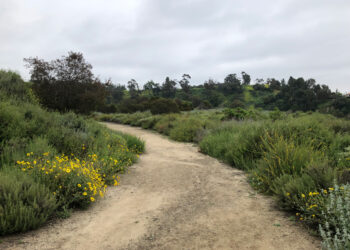
The journey begins at the south end of the parking lot, where a wide, well-graded fire road stretches ahead. This opening section is essentially flat, making it accessible to families with young children, people using strollers, and anyone who prefers a relaxed pace. The footing is stable — packed dirt and gravel — and the path is wide enough for groups to walk side by side.
Along the way, the San Gabriel River is a constant companion. At first, the trail sits well above the water, offering elevated views down into the canyon where the river winds between boulders and sycamores. The sound of the current — sometimes a gentle murmur, sometimes a more assertive rush depending on the season and recent rainfall — provides a natural soundtrack that distinguishes this walk from the typical urban trail.
The Transition: Fire Road to Singletrack
After roughly one mile, the character of the trail shifts. The wide fire road gives way to a narrower singletrack path that dips closer to the river. The terrain becomes more rugged here, with sections of exposed rock and occasional muddy patches, particularly after rain. This is where the park begins to feel genuinely wild, and where casual strollers tend to turn around.
For those who press on, the reward is proximity. The trail descends toward the riverbank, and within another half mile, hikers can reach the water’s edge. Touching the cold, clear water of the San Gabriel River — fed by snowmelt and mountain springs — is a tactile reminder that genuine wilderness exists just minutes from suburbia.
The Boulder Section
The trail’s final stretch dissolves into a jumble of boulders, requiring some basic scrambling to continue. This section has been described by experienced hikers as “moderate” not because of distance or elevation, but because of the uneven footing and the need to navigate rock to rock. The path effectively ends where the boulders become too large and dense to proceed without real effort, roughly in the vicinity of a USGS stream gauging station that monitors the river’s flow.
Most hikers complete the entire out-and-back route in one to one and a half hours at a comfortable pace.
The San Gabriel River: The Park’s Living Centerpiece
It is impossible to discuss Azusa Wilderness Park without spending time on the river that defines it.
The San Gabriel River originates high in the San Gabriel Mountains, fed by tributaries like the West Fork, the East Fork, and the North Fork. By the time it reaches the park, it has already carved its way through miles of rugged canyon, picking up sediment, carving granite, and sustaining a riparian ecosystem that supports everything from native trout to great blue herons.
The river’s significance extends well beyond ecology. It is a critical water resource for Los Angeles County, and the infrastructure that manages it — including Morris Dam, located upstream of the park — plays a central role in the region’s water supply and flood control systems. The Watershed Conservation Authority’s involvement in the park is no accident; the WCA exists specifically to conserve open space and improve public access along the San Gabriel and Lower Los Angeles river systems.
For visitors, the river offers different experiences depending on the season. In winter and spring, after heavy rains, the current runs strong and the canyon resonates with the sound of moving water. By late summer and fall, the flow often diminishes, exposing more of the rocky riverbed and creating shallow pools that attract birds and wildlife. Swimming in the river at the park itself is generally not permitted or advisable — signs direct visitors to higher points in the canyon for water access — but the visual and auditory experience of the river is the park’s most defining feature.
Who Is This Park For? A Breakdown by Visitor Type
One of Azusa Wilderness Park’s greatest strengths is its accessibility. Unlike many trails in the San Gabriel Mountains that demand significant fitness, proper gear, and serious time commitment, this park offers something for nearly everyone.
Families with Children
The flat, wide opening mile of the trail is ideal for young kids who are just developing their legs on outdoor terrain. The river provides a natural point of interest to keep children engaged, and the total distance is short enough to avoid the meltdowns that come with overambitious hikes. Restroom facilities are limited — a portable restroom is available in the parking lot — so plan accordingly.
Dog Owners
The park is dog-friendly, with the stipulation that all dogs must remain on leash and owners must clean up after their pets. The trail’s gentle grade and proximity to water make it a popular choice for dog walkers, particularly on weekday mornings when crowds are thin.
Trail Runners and Fitness Walkers
While the trail is too short for serious distance training, it works well as a quick conditioning run or a midweek cardio session. The flat fire road section offers consistent footing, and the singletrack provides a bit of technical variety.
Nature Enthusiasts and Birders
The riparian corridor along the San Gabriel River supports a surprising diversity of plant and animal life. Hikers with an eye for botany will find native species like Dudleya (liveforever succulents), California sycamores, and various chaparral plants clinging to the canyon walls. Birdwatchers may spot red-tailed hawks riding thermals above the canyon, as well as smaller species that frequent the riverbank.
Photographers
The interplay of light, water, and canyon walls creates compelling photographic opportunities, especially in the early morning and late afternoon when the sun angles through the canyon. The Hilda L. Solis River Overlook provides an elevated vantage point, while the trail’s lower sections offer intimate river shots.
Practical Information: What You Need to Know Before You Go
Parking and Fees
The park has a large lot at the entrance. An Adventure Pass may be required for vehicles parked in the area, as the park sits at the boundary of the Angeles National Forest recreation zone. It is worth checking current requirements before visiting, as enforcement and fees can vary.
Hours and Closures
The park has been subject to periodic closures due to natural hazards. Heavy rains can trigger rockslides in the canyon, and the WCA has temporarily closed the park on several occasions to ensure visitor safety. Before planning a trip, check the Watershed Conservation Authority’s website or call their office at (626) 492-0611 for current conditions.
Sun and Heat
This is an important consideration that many first-time visitors underestimate. The trail offers virtually no shade. The canyon walls provide some relief early and late in the day, but during midday hours — particularly in summer — the exposed trail can become uncomfortably hot. Bring more water than you think you need (at least one liter per person), wear sun protection, and avoid the hottest hours if possible.
Wildlife Awareness
The park sits at the wildland-urban interface, and visitors should be aware of potential encounters with rattlesnakes, insects, and other wildlife. Staying on the established trail and watching where you step — especially in the boulder section — will minimize risk.
Trail Etiquette and Safety
The trail borders private property in some sections, so staying on the established path is both a courtesy and a safety measure. The WCA and trail users have also noted occasional concerns about personal safety, particularly for solo visitors. Hiking with a companion, staying aware of your surroundings, and visiting during busier hours are sensible precautions.
The Bigger Picture: Azusa Wilderness Park in the Regional Trail Network
The park is not an island. It connects — both physically and conceptually — to a much larger network of trails and open spaces in the San Gabriel Valley and the Angeles National Forest.
The trail at the park is technically part of the San Gabriel River Trail, a remarkable 40-mile corridor that stretches from the mountains all the way to Seal Beach on the Pacific coast. While the vast majority of that trail is paved and oriented toward cyclists and casual walkers in the valley below, the Azusa Wilderness Park section offers a wilder, more rugged experience that reflects the trail’s mountain origins.
The WCA has also been working on broader connectivity through its Azusa Foothills Open Space Stewardship Plan, which envisions linking the River Wilderness Park with surrounding open space parcels on Glendora Ridge and in the foothills above Azusa. A 2006 conceptual map envisioned an extensive trail system connecting these properties, though some planned routes have since been closed due to erosion and safety concerns. Community dialogue continues about how best to balance public access with conservation needs and the concerns of neighboring properties.
For hikers looking to extend their day, the park’s location at the canyon entrance means that dozens of more challenging trails are within a short drive. The San Gabriel Canyon offers access to popular destinations throughout the Angeles National Forest, from the East Fork to West Fork to the high peaks of the San Gabriel range.
A Seasonal Guide: When to Visit Azusa Wilderness Park
The experience at Azusa Wilderness Park changes meaningfully with the calendar, and choosing when to visit can make the difference between a good outing and a great one.
Winter (December–February)
Winter brings the most water to the San Gabriel River, and the canyon comes alive with the sound of a full, rushing current. The air is cool, the skies are often clear after storms pass, and the trail is at its most comfortable temperature. The trade-off is that heavy rains can trigger closures. Rockslides are a genuine concern in the canyon, and the WCA has shut the park down on multiple occasions during particularly wet winters. Always check conditions before heading out during this season.
Spring (March–May)
This is arguably the best time to visit. Wildflowers begin to appear on the canyon walls, including native species like Dudleya densiflora, a succulent that clings to rocky outcrops and blooms in delicate clusters. The river maintains good flow from winter runoff, temperatures are mild, and the trail is dry enough for comfortable walking. Spring weekends tend to draw the largest crowds, so weekday mornings offer a more solitary experience.
Summer (June–August)
Summer demands respect. The canyon traps heat, the trail has no shade canopy to speak of, and midday temperatures can easily exceed 90 degrees Fahrenheit. Visitors who insist on summer hikes should start early — ideally before 8 a.m. — carry extra water, and plan to be finished before the sun reaches its peak. The river’s flow typically drops during summer months, but the lower water levels can actually make the riverbank more accessible, with shallow pools forming among the boulders.
Fall (September–November)
Fall offers a return to comfortable hiking conditions. The oppressive heat recedes, the crowds thin out, and the canyon takes on a quieter, more contemplative character. The river runs at its lowest during this period, which can reduce the auditory drama of the experience but opens up more of the rocky riverbed for exploration. The light in late October and November, low and golden, makes fall an excellent season for photography.
The Ecology You Walk Through
It is easy to treat the trail at Azusa Wilderness Park as merely a path from point A to point B. But slowing down and paying attention to the biology of the canyon reveals a surprisingly complex ecosystem packed into a narrow riparian corridor.
The plant communities here exist in distinct layers. Along the riverbank, California sycamores and willows dominate, their roots reaching into the water table that the San Gabriel River sustains even in dry months. These trees provide critical habitat for nesting birds and serve as the structural backbone of the riparian zone.
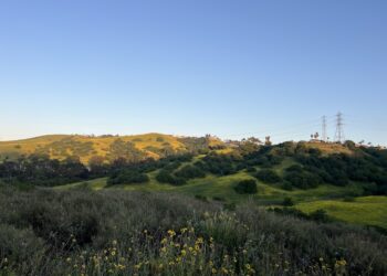
Higher on the canyon walls, the vegetation shifts to coastal sage scrub and chaparral — drought-adapted plant communities that define much of Southern California’s wildland landscape. Buckwheat, California sagebrush, and various species of ceanothus cling to the rocky slopes, their root systems helping to stabilize soil that would otherwise slide into the canyon during heavy rains.
The animal life, while often hidden from casual view, is no less significant. The San Gabriel River supports populations of native fish, including the endangered Santa Ana sucker, a small bottom-dwelling species that depends on clean gravel substrates and clear-flowing water. Reptiles, including western fence lizards and the occasional Southern Pacific rattlesnake, inhabit the rocky terrain. Overhead, raptors patrol the canyon thermals — red-tailed hawks and Cooper’s hawks are the most common — while smaller songbirds work the riverside vegetation below.
This is not pristine, untouched wilderness. The park exists within a landscape shaped by a century of water management, road building, and urban encroachment. But the WCA’s restoration work — particularly the efforts to stabilize the riverbank and reintroduce native plantings — has nudged the ecosystem back toward health. The park serves as a living demonstration that urban-adjacent wildlands can be both preserved and improved through careful stewardship.
Why Azusa Wilderness Park Deserves More Attention
In a region saturated with outdoor recreation options, it is easy for a modest 40-acre park to get lost in the noise. Azusa Wilderness Park does not have the dramatic elevation gains of Mount Baldy, the waterfalls of Eaton Canyon, or the celebrity cachet of Griffith Park. What it has instead is something quieter and, in its own way, more valuable: an honest, unadorned encounter with the natural landscape that exists at the very edge of one of the world’s great cities.
The park represents a particular kind of conservation success — the kind that happens not through grand gestures but through patient, incremental work. A former restaurant site, reclaimed. A river corridor, protected. A trail, maintained. Interpretive signage, installed. It is conservation as civic practice, carried out by agencies like the WCA in partnership with the City of Azusa and the communities that use the space.
For visitors, the appeal is equally grounded. This is a place to walk alongside a river, to listen to water, to watch a hawk circle above a canyon, and to return home within the hour feeling slightly more connected to the physical world. No bucket-list pressure. No Instagram imperative. Just a trail, a river, and the mountains rising above.
Making the Most of Your Visit
Azusa Wilderness Park rewards those who approach it on its own terms. Come early in the morning, when the canyon is cool and the light is soft. Bring water, wear sturdy shoes, and leave the earbuds at home so you can hear the river. Walk the full trail if your fitness allows, or simply sit at the overlook and watch the water move through the canyon below.
Check the WCA website before you go, especially during the rainy season, to confirm the park is open. Respect the trail boundaries, pack out your trash, and keep your dog leashed.
And if you find yourself standing at the end of the trail, balanced on a boulder at the river’s edge, with the sound of water filling the canyon and the city somewhere far behind you — take a moment. This is what it means to live in Los Angeles and still have access to something wild. This is what places like Azusa Wilderness Park exist to protect.
It is a small park with a large purpose, and it is waiting at the mouth of the canyon for anyone willing to make the drive.


