

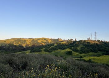
There are places in Southern California where the relentless hum of freeways fades just far enough into the background to remind you that this region was, once upon a time, all hills and open sky. Powder Canyon is one of those places. Tucked into the eastern reaches of the Puente Hills just above the communities of La Habra Heights, Rowland Heights, and Whittier, it sits like a crease in the land — shaded, alive, and quietly extraordinary in a part of the world that most people only ever see from a car window on the 60 Freeway.
This is not Yosemite. It is not the San Gabriels or the Santa Monica Mountains. But Powder Canyon doesn’t need to compete with wilderness icons. It offers something different — something almost more valuable to the millions of people who live within a 20-minute drive of its trailhead. It offers proximity, wildness, and the particular kind of beauty that comes from a landscape that has been carefully preserved while the city grew up around it.
What Is Powder Canyon, Exactly?
Located at the easternmost extent of the Puente Hills Preserve, the Powder Canyon area offers many miles of multi-user trails with connections to the Los Angeles County-managed Schabarum Trail and Schabarum Regional Park. It is managed jointly — the northern half of the Powder Canyon trails are overseen by Los Angeles County Parks and Recreation, while the southern half is administered by the Puente Hills Habitat Preservation Authority.
That dual stewardship tells you something important about this place. It is not an afterthought. Multiple public agencies have invested in keeping Powder Canyon intact and accessible, not because it’s politically convenient, but because the land genuinely matters — ecologically, recreationally, and culturally — to the dense urban communities that surround it.
Lying partially in the Puente Hills Habitat Authority lands and partially in Los Angeles County’s Peter F. Schabarum Regional Park, the loop through Powder Canyon takes hikers through beautiful woodland areas and into a canyon cutting through the Puente Hills before turning around and climbing back over the hills.
The trailhead is accessed primarily via Fullerton Road in La Habra Heights, at an address most GPS systems will find as 2345 Old Fullerton Road. From downtown Los Angeles, that’s roughly 25 miles east. From Orange County, the approach is even simpler — north on the 57 Freeway, west on Pathfinder, south on Fullerton. Either way, you arrive not at some grand gateway with interpretive signage and gift shops, but at a modest horse corral and a wide dirt road that disappears into the trees. That understatement is part of the charm.
The Terrain: From Shaded Canyon Floor to Sun-Scorched Ridgeline
Powder Canyon is not one trail but an entire network of paths that fan out across the eastern Puente Hills, each offering a slightly different character and challenge level.
The Powder Canyon Loop Trail covers 6.8 miles with an elevation gain of 1,233 feet and takes about 3.5 to 4 hours to complete. That places it firmly in the moderate category — demanding enough to feel like a real workout, accessible enough that fit beginners can complete it without suffering. The terrain earns its moderate rating through variety rather than brutality: gradual climbs give way to steeper pitches, wide fire roads narrow into shaded singletrack, and exposed ridgelines alternate with cool canyon bottoms.
For those who want something shorter, the Powder Canyon and Schabarum Loop covers 4.3 miles with an elevation gain of 672 feet and takes roughly two hours to complete. It is frequently praised as an ideal option for social hiking — the kind of trail where you can actually hold a conversation without gasping for breath at every switchback.
At the more compact end of the spectrum, the Black Walnut and Powder Canyon Motorway Loop covers 2.1 miles with an elevation gain of 383 feet and takes about an hour to an hour and a half. This shorter route is especially popular with families and dog walkers looking for a genuine nature experience without committing to a half-day excursion.
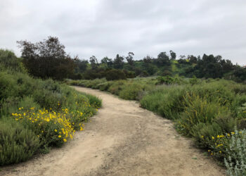
The main Powder Canyon trail begins as an easy, wide dirt road with some tree coverage and access to many other trails. From the horse corral near Old Fullerton Road, the track rolls gently uphill beneath the canopy of large oak trees. It’s that first half-mile — shaded, wide, and pleasantly mild — that tends to seduce first-time visitors into thinking the whole thing will be this easy. It isn’t. But the reward for pushing on is substantial.
After a very short time spent in the ubiquitous sun and grassland typical of the Puente Hills, there’s a pleasant surprise of hiking through a small but dense collection of native oaks. On a hot sunny day, there’s a definite drop in temperature under the canopy — enough to tempt even the most goal-oriented hiker to slow their pace and stay a while.
The Trees: Why Powder Canyon’s Ecology Is Genuinely Remarkable
Here is where Powder Canyon becomes more than just another urban hiking destination. This canyon shelters something rare.
The Powder Canyon area boasts a regionally significant population of southern California black walnut, a large deciduous tree beloved by wildlife for its walnut fruits. Mature oak trees and black walnut trees line Powder Canyon Trail, offering cool respite during summer heat.
The southern California black walnut (Juglans californica) is not the kind of tree that makes the cover of hiking magazines. It doesn’t have the dramatic silhouette of a Joshua tree or the cathedral presence of a coastal redwood. But it is, in the context of Los Angeles County, genuinely uncommon. The Puente Hills are one of only a handful of places in Los Angeles County where this tree is found, and it generally only grows on more moist north-facing slopes or in shady canyons. In the Preserve, it can be found in the Powder Canyon and Hacienda Hills areas.
The ecological significance of these trees extends well beyond their presence on the landscape. Surveys have shown that walnut woodlands can provide habitat for 29 species of birds. The walnuts are eaten by birds and rodent species including the California ground squirrel and the western gray squirrel. Owls use the upper branches as roosts and nesting places, while California ground squirrels dig burrows at the bases of older walnut trees.
Regardless of whether the walnut trees in the Preserve are purely native or the result of some hybridization with cultivated English walnuts, they provide important food and shelter resources for many species of insects, birds, and mammals, and are a beautiful and shady addition to the trails.
Alongside the walnuts, coast live oaks anchor the canyon’s woodland sections. These are old trees — wide-trunked, generously canopied, the kind that make you recalibrate your sense of time when you stop to look up through their branches. Several habitat restoration projects are currently underway in the Powder Canyon area, amounting to almost 90 acres of native vegetation that can be enjoyed along the trails. That number — 90 acres of active restoration — is not a small thing. It represents a sustained, deliberate effort to return this landscape to ecological health, undertaken by the Puente Hills Habitat Preservation Authority in partnership with volunteers and conservation organizations.
The Trails: Your Options at Powder Canyon
The trail network inside Powder Canyon is interconnected enough to allow for creative route-building, but named clearly enough that navigation isn’t overly complicated. Here are the key arteries of the system:
Powder Canyon Trail is the backbone. Wide, well-maintained, and shaded at its lower elevations, it functions as both a destination in itself and a connector to the rest of the network. Most loops in this area use it as a starting and ending segment.
Black Walnut Trail branches off to the right roughly 0.6 miles in from the main trailhead. By the junction with the Black Walnut Trail, the shade of the canyon’s woodland sections gives way to open sun again. This spur offers more exposed terrain and harder climbing — suited to those who want to push their heart rate and earn their views.
Purple Sage Trail is where the serious elevation lives. Inclines on Purple Sage Trail and Black Walnut Trail offer more rigorous hiking, biking, and riding terrain. If you arrive at Powder Canyon and find the main trail too gentle, Purple Sage will recalibrate your expectations quickly. The trail is named for the dominant shrub along its exposed sections — massive clumps of purple sage that can perfume an entire hillside after rain.
Schabarum Trail Extension is widely considered the gem of the northern sector. The Schabarum Trail Extension features a beautiful, tree-covered set of switchbacks, and a thrilling, mile-long descent that becomes progressively steeper toward the bottom. Mountain bikers in particular speak reverently about this section.
The full loop through Powder Canyon eventually delivers you to the Peter F. Schabarum Regional Park, where the trail puts you right in front of a large equestrian complex with trailer parking. The park also has picnicking areas, where you may find people relaxing on blankets or at tables while equestrians practice their riding skills or trot past on the trails.
That moment — stepping out of the canyon and into the organized, park-bench-and-picnic-table world of Schabarum — is one of the more interesting transitions in LA-area hiking. You go from feeling genuinely remote to standing beside a manicured county park in the span of about 50 steps. It is, in its own way, a perfect metaphor for Southern California itself: nature and suburb in constant, uneasy, sometimes beautiful adjacency.
Who Uses Powder Canyon?
The short answer is: everyone. And that is part of what makes this place special.
More popular with equestrians — there are centers and corrals at either end of the canyon — this route appears to be more lightly traveled by hikers than others in the Puente Hills, and at times, you may end up having the entire place to yourself. That is increasingly rare in the Los Angeles hiking scene, where popular trails like those in Griffith Park or the Santa Monica Mountains can feel like open-air malls on a weekend morning.
Hikers use Powder Canyon for everything from casual morning walks to training runs to multi-trail explorations that can stretch to seven or eight miles. Mountain bikers have built a loyal community around the network, particularly the dirt road climbs and the singletrack descents that reward those willing to seek them out. Within the broader Powder Canyon loop, there are two other dirt roads and many hidden singletracks that can be combined into many shapes for longer, more challenging rides.
Dog owners are a constant presence on the trails, though leash rules are enforced and tick awareness is genuinely important — particularly in the spring months when the grass is high and the warnings from fellow trail users about ticks are frequent and well-intentioned.
Birders find Powder Canyon quietly rewarding. The walnut and oak woodlands attract a diversity of species that you simply won’t encounter in the sage scrub and chaparral of the more exposed Puente Hills sections. Early morning visits, particularly in spring and fall, can yield a remarkable number of species without any particular effort.
Views, Light, and the Character of the Place
Powder Canyon is not a trail you hike for one signature panorama. It is a trail you hike for the accumulation of smaller moments — the way the light filters through oak canopy in the early morning, the smell of sage on a warm afternoon, the sight of a red-tailed hawk banking lazily over the ridge.
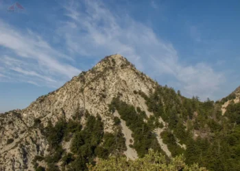
That said, the views from the upper sections of the canyon and the connecting trails are genuinely excellent. The scenic trail through the Puente Hills Reserve offers stunning views of the San Gabriel Mountains. On a clear winter day following a rain — when the air scrubs clean and the mountains emerge with startling definition — those views are among the best available from any trail this close to the urban core of Los Angeles.
On a clear day, from the higher points of the network, you can see Catalina Island and the mountains simultaneously — with La Puente on one side and La Habra, Whittier, and Buena Park on the other. It is a view that captures the particular geography of Southern California better than almost any other vantage point in the region: the ocean to the southwest, the mountains to the north, and the seemingly endless residential grid spread out in every direction below.
Higher up on the Schabarum Trail, there is a spot where prickly pear cacti and California sagebrush cover the hillside above a suburban tract at the end of Azusa Avenue. Combined with the manicured space of Schabarum Regional Park and the distant San Gabriels, it creates a compelling scene where civilization butts up against the wild — and the views improve as the trail gains elevation.
Practical Information for Your Visit to Powder Canyon
Getting There: From Los Angeles, take the 10 Freeway east to the south 605 freeway, then the Pomona Freeway (60) east. Exit at Fullerton Road. Turn right onto Old Fullerton Road. The park is located at 2345 Old Fullerton Road. From Orange County, take the 57 Freeway north and exit at Pathfinder Road, turn left (west). At Fullerton Road, turn left (south), then right on Old Fullerton Road.
Hours: The trail network is open sunrise to sunset. Trails close when the sun sets below the horizon. Seasonal adjustments apply during summer months, so checking the Puente Hills Habitat Preservation Authority website before visiting is always a good idea.
Closures After Rain: This is critical and often catches first-time visitors off guard. Trails in this area are closed for 48 hours after it has rained. The soils in the Puente Hills are clay-heavy and can become deeply rutted when wet, damaging both the trails and the surrounding habitat. The 48-hour closure is enforced, and it is also genuinely necessary for the long-term health of the trail system.
E-Bikes: E-bikes are not allowed on this trail system.
Water: Bring more than you think you need. There is no water on the trail, and the exposed sections of the upper canyon can be brutally hot from late spring through early fall. Two liters minimum for the full loop; more on warm days.
Dogs: Welcome, but must remain on leash. Given the tick population and the proximity to active wildlife habitat, checking your dog thoroughly after any visit is strongly advisable.
Parking: There is a small parking area accessible via the dirt road entrance off Old Fullerton Road near the horse corral. Overflow parking options along the road are limited, so arriving early on weekends is genuinely useful advice, not just a polite suggestion.
The Bigger Picture: Powder Canyon and Urban Conservation
It is worth pausing to consider what Powder Canyon actually represents in the context of Southern California’s conservation history.
The Whittier-Puente-Chino Hills ecosystem sits at the juncture of Southern California’s four most populous counties. This hillside ecosystem remains surprisingly intact and is an integral part of the southwest eco-region. As an epicenter of extinction, it often ranks in the top four U.S. regions at risk for species loss and is one of 25 extinction hotspots in the world.
That context reframes Powder Canyon entirely. This is not simply a pleasant place to get some exercise. It is a fragment of functioning habitat embedded in one of the most densely developed urban regions on earth — a place where bobcats still roam, where rare trees still grow, where migratory birds still stop to rest in the oak canopy, and where the soil still holds the ecological memory of a landscape that predates the freeway by millions of years.
The Puente Hills Habitat Preservation Authority, which manages the southern portion of the Powder Canyon trail network, was created specifically to protect this corridor. Several habitat restoration projects are currently underway in the Powder Canyon area, amounting to almost 90 acres of native vegetation. That work — unglamorous, incremental, and largely invisible to casual trail users — is what keeps Powder Canyon from becoming another hillside of invasive grasses and eroded fire roads.
When you hike Powder Canyon, you are not just visiting a park. You are walking through an active conservation project, one whose success depends in part on the continued engagement of the people who live nearby and use these trails. That is a responsibility worth acknowledging, even on a Tuesday morning when you just wanted to clear your head.
When to Go
Powder Canyon rewards visits in every season, but the optimal windows cluster around two periods.
Late winter and early spring — roughly February through April — is when the hills are greenest, the air is cleanest after winter rains, and the wildflowers begin to emerge along the trail margins. This is also when the walnut trees flush with new leaves, turning the canyon a fresh, almost luminescent green. The views of the San Gabriel Mountains, still carrying snow on their upper ridges, are at their most dramatic during this period.
Fall — October through November — offers the second peak window. The summer heat has broken, the crowds have thinned, and the deciduous black walnuts begin to turn, adding color to a landscape that can feel monochromatic in the dry months. Dawn visits during fall are particularly rewarding for birders, as migratory species move through the corridor.
Summer hiking is entirely possible but requires real respect for the heat. Start before 8 AM, carry abundant water, and plan your route to maximize time in the shaded canyon sections. The exposed ridgeline sections of the Schabarum Trail in midsummer are not a place to be underprepared.
Final Thoughts on Powder Canyon
There is something instructive about the existence of Powder Canyon. It was not inevitable. The hills it occupies could have been subdivided, graded, and built upon decades ago — and in fact, much of the land around it was. The fact that this canyon still exists as a functioning piece of nature, accessible to millions of people, is the result of deliberate choices made by conservationists, public agencies, and communities over many years.
Powder Canyon is the answer to a question that Southern California asks constantly: can wildness and density genuinely coexist? Standing in the oak canopy on a quiet weekday morning, listening to birds and watching sunlight break through the leaves, the answer feels obvious. Of course they can. They already do.
For anyone who lives in the eastern Los Angeles Basin or northern Orange County, Powder Canyon should be on regular rotation. Not just as a workout venue, not just as a dog-walking destination, but as a place to reconnect with the landscape that underlies the whole of this improbable, sprawling, endlessly fascinating region. The canyon is patient. It has been here longer than the freeways, longer than the suburbs, longer than anyone can fully account for. It will be here when you show up.
Powder Canyon trailhead is located at 2345 Old Fullerton Road, La Habra Heights, California. For current trail conditions and seasonal closures, visit habitatauthority.org.


