
The Pacific Coast Highway doesn’t merely connect two points on a map. It serves as a continuous revelation, a 650-mile stretch of asphalt that traces the edge of the American West with the kind of dramatic flair that would make any Hollywood screenwriter envious. This isn’t just a road—it’s a character study of California itself, revealing its contradictions, its beauty, and its restless, searching spirit.
Every bend in this legendary route delivers something unexpected. Fog-shrouded redwood forests give way to sun-scorched bluffs. Sleepy fishing villages sit within driving distance of glamorous resort towns. The Pacific Ocean, that vast and temperamental companion, remains a constant presence—sometimes calm and turquoise, other times gray and pounding against rocks with theatrical fury.
The Case for Driving Slow
Modern travel culture celebrates efficiency. We’ve grown accustomed to treating journeys as obstacles between departure and arrival, something to be minimized rather than savored. The Pacific Coast Highway demands a different approach entirely.
This road punishes impatience. Its hairpin turns, narrow lanes, and frequent pullouts require attention and respect. But this isn’t a bug—it’s a feature. The PCH forces travelers to slow down, to notice, to breathe. In an age of frantic schedules and digital distraction, this mandatory deceleration feels almost therapeutic.
The ideal PCH road trip unfolds over at least four or five days, though a week allows for the kind of spontaneous detours that often become the trip’s most memorable moments. Rushing through defeats the purpose entirely. The highway reveals itself to those who approach it with patience, rewarding extended attention with secret coves, unexpected wildlife sightings, and conversations with locals who’ve built their lives along this precarious edge of the continent.
Traveling from north to south positions drivers on the ocean side of the road, making pullouts safer and views more immediate. The afternoon light also tends to favor this direction, painting the western horizon in the golds and oranges that have drawn painters and photographers to this coastline for generations.
Where the Redwoods Meet the Sea
The northern stretch of the PCH—technically beginning where Highway 1 branches from Highway 101—passes through some of the most haunting landscapes in North America. Here, ancient redwood forests descend toward the ocean, their massive trunks emerging from fog like columns in a cathedral built by time itself.
Mendocino County feels like stepping into a novel. The town of Mendocino, perched on a headland above the crashing surf, maintains a Victorian character that has attracted artists and writers for decades. Its wooden water towers, white-steepled churches, and weathered clapboard buildings could be mistaken for New England if not for the Pacific thundering just below.
The coast along this stretch rarely offers easy access. Dramatic cliffs and treacherous rocks have claimed countless ships over the centuries, earning portions of this region names like “Graveyard of the Pacific.” Point Arena Lighthouse, standing sentinel on a particularly exposed headland, offers tours that include stories of the shipwrecks and heroic rescues that defined life here before modern navigation.
Inland excursions reward the curious traveler. Anderson Valley, just an hour east, has emerged as one of California’s most exciting wine regions, specializing in the cool-climate varietals that struggle in Napa’s warmth. Pinot Noir and Gewürztraminer reach their apotheosis here, and the tasting rooms maintain a low-key atmosphere that the more famous wine regions long ago abandoned.
Fort Bragg, once a logging town, has reinvented itself around tourism and fishing. Its harbor provides a working glimpse of commercial fishing operations, while Glass Beach—where decades of dumped glass have been tumbled smooth by the waves—offers a strange sort of beauty born from environmental transgression and nature’s patient response.
Sonoma Coast: Wild Beauty Untamed
South of the Mendocino border, the Sonoma Coast State Park stretches for seventeen miles, presenting some of the most accessible yet untouched shoreline in California. This section of the highway climbs and dives with stomach-dropping frequency, each crest revealing another vista of sea stacks, hidden beaches, and windswept bluffs.
Goat Rock Beach, where the Russian River meets the Pacific, hosts one of the largest harbor seal colonies on the California coast. From spring through fall, hundreds of seals haul out on the sand, nursing their pups and barking at the waves. The seals appear remarkably unbothered by the presence of human observers, though regulations wisely maintain a buffer zone.
Bodega Bay carries its own peculiar fame as the setting for Alfred Hitchcock’s “The Birds.” The real town bears little resemblance to the film’s scenes of avian terror, but the Potter Schoolhouse still stands, and the Tides Wharf (though rebuilt since filming) continues serving fresh Dungeness crab to visitors who arrive expecting drama and find instead a charming fishing village.
The food along this stretch deserves particular attention. Oysters from Tomales Bay, harvested just inland, rank among the finest in the world. Roadside shacks and casual restaurants serve them raw, grilled, or prepared in countless other ways, always accompanied by crusty bread and local wine. This is not refined dining—it’s elemental eating, the taste of the sea consumed within sight and smell of its source.
Point Reyes: A Geological Detour
Just north of San Francisco, the Point Reyes National Seashore occupies a chunk of land that isn’t technically part of North America at all. Sitting on the Pacific Plate, this triangular peninsula is slowly grinding its way northwest, separated from the continental plate by the San Andreas Fault.
The geology creates an atmosphere of otherworldliness. Tule elk roam the coastal grasslands, descendants of herds that were nearly extinct a century ago. The Point Reyes Lighthouse, accessible via 300 steps cut into the cliff face, occupies one of the foggiest locations on the entire West Coast—which is precisely why it was built there, to warn ships away from the treacherous rocks below.
The pastoral interior of Point Reyes has supported dairy farming since the 1850s. Several historic ranches still operate, their weathered barns and grazing cattle adding an agrarian charm to the otherwise wild landscape. Point Reyes Station, the small town serving as gateway to the peninsula, offers farm-to-table dining that takes the concept literally—the cows producing the cheese on your plate may be visible through the restaurant window.
Drake’s Beach, named for the English explorer who may have landed here in 1579, presents a gentler face than the peninsula’s outer shores. Protected from the full force of the Pacific by the surrounding headlands, its waters attract swimming on the rare warm days when fog doesn’t blanket the coast.
The San Francisco Interlude
The PCH technically routes through San Francisco, crossing the Golden Gate Bridge before threading through the city’s western neighborhoods. Most travelers treat the city as an extended pause rather than a pass-through, and rightfully so—San Francisco rewards exploration on its own terms.
The city’s relationship with the automobile has always been complicated. Its famous hills, narrow streets, and limited parking make driving more frustrating than pleasurable within city limits. But approaching from the north, watching the rust-red towers of the Golden Gate emerge from the fog, delivers one of the great arrivals in American motoring.
South of the city, Highway 1 traverses the developed Peninsula before reaching the coast again at Pacifica. Devil’s Slide, a stretch of road carved into unstable cliffs, once closed repeatedly due to landslides. A tunnel bypass now handles through-traffic, but the original roadbed has been converted to a hiking and cycling trail, offering views even more dramatic when experienced at walking pace.
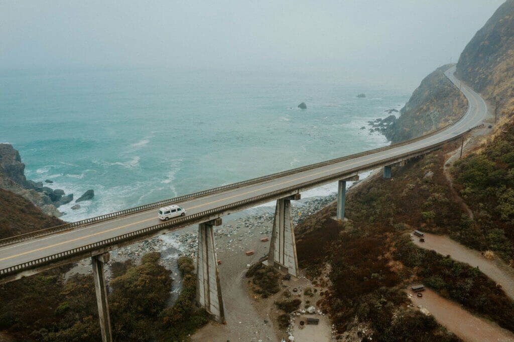
Big Sur: The Main Event
No stretch of the PCH commands more reverence than Big Sur. This eighty-mile section between Carmel and San Simeon represents the highway’s most spectacular achievement, a ribbon of road carved into cliffs that drop directly into the ocean hundreds of feet below.
The engineering required to build this road in the 1930s bordered on the impossible. Workers dangled from ropes to drill into the rock face. Convicts from San Quentin provided much of the labor. The Bixby Creek Bridge, an elegant concrete arch spanning a deep canyon, has become perhaps the most photographed structure on the entire route—and likely the most cursed by the highway workers who must constantly repair damage from tourists stopping in dangerous locations to capture its image.
Big Sur as a place resists easy definition. No incorporated town exists, just a scattering of businesses, campgrounds, and private residences spread along the highway. State parks protect much of the land, including Pfeiffer Big Sur, Julia Pfeiffer Burns, and Andrew Molera. Each offers hiking trails that climb from ocean level into the redwoods and back.
The area has attracted those seeking refuge from mainstream society since the early twentieth century. Henry Miller lived here for nearly two decades, writing about Big Sur’s “healing quality” and its appeal to “fugitives from civilization.” The Beat poets found inspiration in its wildness. Later arrivals established hot springs, meditation centers, and various intentional communities that continue in altered form today.
McWay Falls, an eighty-foot waterfall that plunges directly onto a beach within Julia Pfeiffer Burns State Park, provides Big Sur’s most iconic single image. The falls are visible only from an overlook trail—the beach itself is inaccessible—but this forced distance somehow enhances the scene’s beauty, keeping it pristine and dreamlike.
Hearst Castle: Dreams Made Concrete
At the southern end of the Big Sur coast, above the town of San Simeon, sits one of America’s strangest monuments to personal ambition. William Randolph Hearst, the newspaper magnate whose life inspired “Citizen Kane,” spent three decades building an estate that defies easy categorization.
Hearst Castle combines elements of Spanish cathedrals, Italian villas, and Hollywood fantasy into a compound that sprawls across 127 acres atop a coastal hill. Hearst called it “La Cuesta Encantada”—the Enchanted Hill—and his obsessive collecting filled its rooms with one of the largest private art collections ever assembled.
The guided tours offered by California State Parks (which has operated the property since 1958) reveal both the magnificence and the absurdity of the place. Neptune Pool, with its Roman temple façade, was drained and filled three times during construction because Hearst kept changing his mind. The Gothic Suite contains genuine medieval furnishings surrounded by modern amenities. Zebras, descendants of animals from Hearst’s private zoo, still roam the surrounding hills.
The castle serves as a useful reminder of the fortunes that have always flowed through California, and of the dreams—sometimes grand, sometimes questionable—that those fortunes enabled.
The Central Coast: Abundant and Accessible
South of San Simeon, the highway descends from the dramatic cliffs of Big Sur into a gentler landscape of rolling hills, protected bays, and some of California’s most productive agricultural land.
Morro Bay, distinguished by the 576-foot volcanic plug rising from its harbor, offers whale watching, kayaking, and some of the freshest seafood on the coast. The “Morro Rock” has been protected since 1968, home to nesting peregrine falcons and a symbol of the town’s identity.
San Luis Obispo, a few miles inland, combines a college-town atmosphere with genuine historic charm. Its Mission San Luis Obispo de Tolosa, founded in 1772, stands at the center of a walkable downtown filled with independent shops and restaurants. The Thursday night farmers market transforms the main street into a community celebration that draws visitors from throughout the region.
The wine regions around Paso Robles and Edna Valley have emerged as serious destinations, producing bold Rhône varietals and cool-climate Pinot Noir that rival anything from more famous appellations. The tasting room culture here tends toward welcoming rather than intimidating, with winemakers often pouring their own wines and happy to discuss their craft at length.
Santa Barbara: The American Riviera
As the PCH approaches its southern terminus, it encounters Santa Barbara, the city that has most successfully captured the Mediterranean atmosphere its Spanish colonial architecture suggests. The white stucco walls, red tile roofs, and palm-lined streets create a coherence rare among California cities—the result of strict design guidelines adopted after a 1925 earthquake destroyed much of the downtown.
The Santa Barbara Courthouse, built in 1929, may be the most beautiful public building in California. Its Moorish details, hand-painted ceilings, and panoramic tower views make it worth visiting even for travelers with no official business inside.
The waterfront, known as Stearns Wharf and the adjacent harbor, provides a pleasant conclusion to days of dramatic coastal scenery. Here the Pacific feels almost tame, its waves lapping gently against a sandy beach that stretches for miles in either direction. Pelicans dive for fish. Sailboats dot the horizon. The mountains rise immediately behind the city, creating the unusual geography that allows snowboarding and surfing on the same day.
The Road Ends, The Memory Remains
The Pacific Coast Highway officially concludes in Orange County, where it merges with Interstate 5 amid the sprawl of Southern California. This anticlimax is almost deliberate, as if the road wishes to underscore the specialness of what came before by providing such an ordinary ending.
But endings are never really the point of journeys like this one. The PCH lives in the memories it creates, the perspectives it shifts, the conversations it inspires. Travelers who make this drive inevitably find themselves changed by it, their sense of scale recalibrated by the encounter with such vast and varied beauty.
California has always been a state of reinvention, a place where people come to start over, to become new versions of themselves. The Pacific Coast Highway embodies this spirit perfectly. Each curve reveals something unexpected. Each vista prompts reconsideration of what came before. The journey transforms both landscape and traveler, leaving neither quite the same as when they began.
Those who drive the PCH carry something of its wildness forward into their ordinary lives—a memory of fog burning off above the waves, of seals barking on distant rocks, of that particular quality of light that exists nowhere else on Earth. The road stays with you. It was designed to do exactly that.


